
Tracking the Tropics: Nadine and Oscar Provide October Surprises
- northfloridaams
- Oct 19, 2024
- 4 min read
The 2024 hurricane season continues with a backloaded season. In the span of 24 hours, we've quickly had Nadine and Oscar form in the Caribbean and Bahamas, respectively, after a short lull following Milton. Since Nadine is quickly approaching landfall, we'll start there! Tropical Storm Nadine
Nadine quickly formed yesterday/into the early morning hours today. This was an image from 6:00PM ET yesterday that shows the formative stages. We can see the low-level flow in red here, with our trade winds starting to curve around our low pressure system/PTC15. This was still a bit elongated at the surface but clear banding features were beginning. We can see in green the upper-level outflow with the ULAC associated with PTC15/future Nadine (assisted by the stalled frontal zone):

Visible Loop of Nadine from Yesterday Evening (10/18/2024)
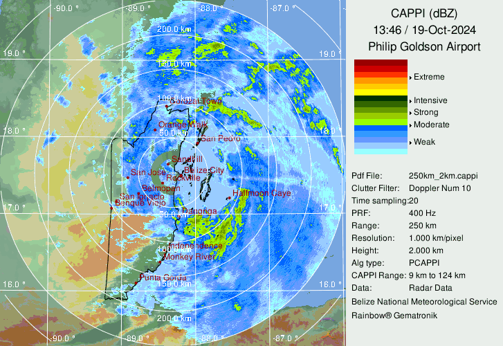
Nadine Currently Making Landfall
Nadine is essentially making landfall at the current moment of this writing (12PM ET; 1600 UTC). NHC recon was tasked for later today, but given the quicker than anticipated landfall, this mission has been canceled and hastily transitioned to Oscar (more on this system later). A weather station in San Pedro in the southern Yucatan Peninsula recently reported a sustained wind of 55 mph with gusts of 67 mph.
Visible Imagery of Nadine at Landfall
Radar Imagery from Belize
Rain is the Biggest Threat with Nadine
The main threat from Nadine remains localized flooding and the potential for landslides. This run from the 00z GFS last night shows the potential for heavy precipitation along the eastern coast of the Yucatan Peninsula near popular tourist destinations of Cozumel and Costa Maya.
Total Rainfall Accumulation over the next 4 Days (GFS 00z)

Future Forecast for Nadine
The cold front that pushed down into the GOM has not only given us a 'false' fall here in Florida (it's going to warm back up, sorry guys) but behind it we have subsidence dump/high pressure extending all the way into the BOC. While the ECMWF 00z ensembles keep the core of Nadine out of the Bay of Campeche and tracking across Central America into the eastern Pacific, convection displaced to the north will also potentially create flooding and landslide conditions in southeastern Mexico (as seen in the product above).
ECMWF 500mb Height Anomalies and EMCWF Ensemble runs from 00z


Tropical Storm Oscar
Tropical Storm Oscar was quite the breakfast surprise, with the NHC giving the odds of formation to be 30% at 5AM. A microwave imagery from early this morning (around ~7:00AM ET) showed diurnal maximum, or DMAX (the period of the day where convection is most prominent to pulse/occur from the central radius of a tropical cyclone and propagate outwards) provided the necessary consolidation for the inner-core of 94L/now Oscar. We can see this in the infrared loop below and the microwave pass showing the recent development of the inner core.
16-hour Loop of Oscar from Infrared Perspective
Microwave Imagery of Oscar Showing Inner Core Formation

NHC Quickly Provides Observational Resources for Oscar
As early morning visible satellite imagery came in, in addition to the microwave pass from above, it was clear that 94L had gained tropical storm characteristics. NHC updated the chances of formation to 60% at 8AM before a special update was provided at 9AM ET to update the chances of formation to 90%. It was evident at 10AM ET that Oscar had formed an inner core, and advisories were issued at 11AM ET. Satellite imagery below show the formation of two vertical hot towers (VHTs, highlighted in red) from the early morning visible to help further establish the inner core and cold dense overcast (CDO). Meso sector 1 for GOES-16 was quickly transitioned to Oscar, and a previous recon mission for Nadine was canceled and transferred to tasking for Oscar:

Potential for 'Microcane' Oscar
The small inner core of Oscar provides the potential for a quick ramp up in intensity, and the NHC mentioned this in their initial 11AM discussion. It does appear Oscar is quickly wrapping up, and environmental conditions over the next ~24 hours are favorable for additional strengthening. As of this writing, recent recon found the central pressure to be 991mb.
Recon pass from 1:00PM ET

Future Guidance for Oscar
Neither Nadine nor Oscar pose a threat to Florida, as the steering flow should keep both systems safely away from areas still in recovery after Helene and Milton. One of two possible solutions exist for Oscar.
(1) Oscar weakens significantly as the shear increases, and the core becomes abruptly disrupted. This likely will lead to some sort of decoupling phase, with the low-level circulation continuing westward with the low-level flow into Cuba, and the mid-to-upper level circulation/convection being quickly displaced to the northeast. This is the 12z GFS deterministic solution:
(2) Oscar remains somewhat intact, and the system is initially steered westward towards/over Cuba by a narrow mid-level ridge to the north before an amplifying/retrograding trough induces a northeastward motion. This is the solution of the 06z ECMWF deterministic run:
As alluded to above, shear will become an issue for Oscar down the road. The 00z HWRF run was one of the few hurricane models that correctly captured the 'micro' inner core of Oscar. The model shows directional shear starting in ~24 hours, which should quickly disrupt the inner core of Oscar (smaller core systems are more subject to rapid strengthening/weakening from directional shear):

Initial NHC Track Guidance (issued at 11AM ET)

Final Thoughts on Nadine and Oscar: Size Doesn't Matter It's interesting to see the comparison of size between Nadine and Oscar. Nadine formed from more of a traditional Central American Gyre (CAG) formation process, which contributed to the larger diameter of the system. Meanwhile, Oscar formed exclusively from an African Easterly Wave and had to form the smallest core possible to survive a rather dry background environment (yup, this was the same invest/wave that was responsible for the 40 mph winds recorded over the Cabo Verde islands a week ago). Here is a side by side comparison of the two system right as Nadine was preparing for landfall, with recon finding the much smaller Oscar was already pushing close to hurricane force winds:

-- Matthew Weiberg


Comments